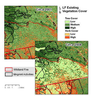
Pictures of what the LF program incorporates with the LANDFIRE logo on the left and USFS and DOI on the right
LANDFIRE - multi-partner wildland fire, ecosystem, and wildland fuel mapping project USFS DOI
[Skip to Content]
  Button for Who Are We
 
 
Homepage » Data Products Overview » LF 2001

LANDFIRE (LF) 2001


Data Products:Reference  ∕  Disturbance  ∕  Vegetation  ∕  Fuel  ∕  Fire Regime  ∕  Topographic  ∕  Who are We
     Notifications Alerts

Latest NewsLatest News

Get Data

Refresh Overview LF 2001 (LF 1.0.5)

LF 2001 enhanced the layers of the LF National data set to provide a foundation upon which to build an updated geospatial data set. The enhancements were developed to facilitate comparative analyses, evaluate trends, and potentially monitor changes over time. In particular, LF 2001 enhancements addressed:

Existing vegetation cover and height (EVC & EVH) were remapped in forested areas and all products were updated to reflect refined existing vegetation. Updates included changes caused by 1999 - 2001 fires. LF 2001 was used as an input to strategic wildland fire management decision support systems.

Product categories:


LF 2001 Data Access

Download Data

See Data Products Version Table


Users may experience intermittent service Thursday evenings due to routine maintenance.
The LF Map Viewer (DDS) will be down every 3rd Wednesday from 8 am - 10:00 am (CDT) for routine maintenance.
URL: https://www.landfire.gov/
To view and print a PDF you must obtain and install the Acrobat® Reader, available at no charge from Adobe Systems.
*DOI and USGS link and privacy policies apply.
Looking for something: Site Map   /   Search
Page Contact Information: LF Helpdesk